1920's Roating beacon and tower


1920's Roating beacon and tower
Google Maps Google Maps Birds Eye Birds Eye Yahoo Maps Yahoo Maps
By: kjfitz @ 2008-04-17 19:57:22
Description: 
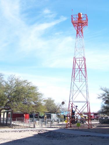
Rotating beacons were used to make night flying safer. Visible from 40 miles, beacons also identified obstructions and distance from origin on airways. This tower and light are much like the "Lindy Light" dedicated in 1927 by Charles A. Lindbergh at Davis Monthan Field.
Location: Tucson, Arizona (AZ), United States (US)
@ 32.14021000, -110.86580100
Views: 209
Rating: Rate as 1 Rate as 2 Rate as 3 Rate as 4 Rate as 5 Rate as 6 Rate as 7 Rate as 8 Rate as 9 Rate as 10 Unrated

Categories

Download

Tell
Share
Update Imagery

Pics: (1)
Nearby Maps (50 km): (282)

270 more...


Post a Comment: (Policies)

Please log in if you don't want to post anonymously (anonymous users cannot post links)

Name: Anonymous
Comment:
Anti-Spam Code: Please enter the code below:
Please enable images and enter code to post