From Installation Action Plan for the Sierra Army Depot, p. 30:
The 1960 Demolition Area is located in the northern
portion of SIAD. The site is approximately 1700 feet
by 2000 feet (approximately 80 acres). This area was
developed during the 1960s when the UBG demolition
area was closed for construction. During 1960-1961, a
group event of 36, 500-pound bombs were detonated
at a rate of 12 groups per day (432 bombs per day).
Some of the metal fragments from this activity remain on
the surface today. CS tear gas grenades were also
detonated at a rate of 200 to 248 pounds per day for a
3 month period in 1961. During the 1970s, NIKE
Hercules XM-30 motors were fired in silos on the site.
The solid-based propellant was burned in the silos
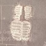
during the firings. Approximately 24 surface depressions
(trenches) created by detonated bombs are
located at the 1960 Demolition Area. A review of
aerial photographs indicate that the trenches are 300 to
500 feet long, 150 feet wide and up to 20 feet deep.
1960 Demolition Area, Sierra Army Depot
© Google Maps

© Bing Maps
By AlbinoFlea @ 2005-09-07 14:45:23


Anonymous
@ 2005-09-07 19:34:56
looks like two giant upside down bootprints.