Login or Create Account to Submit Maps

Boonsboro 'Silo'


Rate: Bad [ Rate as 1 Rate as 2 Rate as 3 Rate as 4 Rate as 5 Rate as 6 Rate as 7 Rate as 8 Rate as 9 Rate as 10 ] Good
Boonsboro 'Silo'
Boonsboro 'Silo'
Boonsboro 'Silo'
Google Maps Google MapsLive Local Live LocalYahoo Maps Yahoo Maps
Name:Boonsboro 'Silo'
Description:
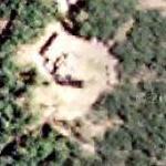
This facility, clearly visible above the trees from several major highways, is located on a mountain called Lambs Knoll.

Speculation is that it is a hardened radio relay with a bunker under it. Built in the 60's and still manned by "men in blue jumpsuits."
More Info:Link

Submitted By:kjfitz @ 2005-07-19 21:44:40
Last Modified:kjfitz @ 2006-03-23 18:38:02

Google Earth:Download to Google Earth (KML)
Google Maps:View in Google Maps
Live Local:View in Live Local
Yahoo Maps:View in Yahoo Maps
Latitude:39.44836000
Longitude:-77.62716700

Views:521
Map Rating:5.40 (based on 9 votes)
Rate This Map:Bad [ 1 2 3 4 5 6 7 8 9 10 ] Good

City:Boonsboro
State:Maryland (MD)
Country:United States (US)

Thumbnails
Google Maps:AlbinoFlea @ 2007-11-11 00:54:18
Live Local:kjfitz @ 2006-03-23 18:37:41
Yahoo Maps:AlbinoFlea @ 2006-05-19 14:20:03

Categories:
Tell:
Share:

Nearby Maps: (64)
  1. George Alfred Townsend War Correspondents Arch (4.9km)
  2. (The First) Washington Monument (5.8km)
  3. Antietam Aqueduct (10.8km)
  4. Aircraft in Flight (14km)
  5. Maryland Correctional Institution - Hagerstown (14.6km)
  6. Brunswick Railroad Museum (15.1km)
  7. Chesapeake and Ohio Canal - Lock 30 (15.3km)
  8. Brunswick Roundhouse (Demolished in 1996) (15.3km)
  9. Brunswick Waste Treatment Plant (15.6km)
  10. Remains of Catoctin Aqueduct (16.1km)
54 more...


No comments

Post a comment: [Policies]

Please log in if you don't want to post anonymously.

Anonymous users cannot post links.

Name: Anonymous
Comment:
Anti-Spam Code: Please enter the code below:
Please enable images and enter code to post

Pre-Caching Vote image