NSA Utah Data Center

NSA Utah Data Center
Google Maps Google Maps Bing Maps Bing Maps Yahoo Maps Yahoo Maps
By: skyeye @ 2011-01-15 16:34:08
map #109903
Description:
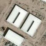
The National Security Agency and the U.S. Army Corps of Engineers broke ground in January 2011 on a $1.2 billion data center at Camp W.G. Williams National Guard Post here. The massive, one million square-foot facility currently is the largest U.S. Department of Defense project in the nation.

It looks like the airfield is being demolished.

http://cryptome.org/dodi/nsa-utah-data-02.pdf
http://www.globalsecurity.org/military/facility/camp-wg-williams.htm
http://www.mytopo.com/maps/?lat=40.4274&lon=-111.9341&z=15
More Info:www.globalsecurity.org
Location: Camp Williams, Utah (UT), US
@ 40.42721800, -111.93270200
Views:
840
Views by date
Rating: Rate as 1 Rate as 2 Rate as 3 Rate as 4 Rate as 5 Rate as 6 Rate as 7 Rate as 8 Rate as 9 Rate as 10 Unrated

Categories

Download

Nearby Maps (50 km): (285)

273 more...
Save & Tell
+ My Favorites Email This Map
Share
Your Pics Your Story
Update Thumbnails
Google Google Bing Bing Yahoo Yahoo


Comments (2)

Feed Feed Post a Comment

hhgygy @ 2012-04-10 02:39:06
hhgygy picture
There's been an update on which some of the buildings are already visible. The update is in the historical imagery though.
hhgygy @ 2012-04-10 02:41:07
hhgygy picture
Bing Maps have also updated their image but it looks older than the latest in GE.

Post a Comment: (Policies)

Please log in if you don't want to post anonymously (anonymous users cannot post links)

Your Name: Anonymous
Comment:
Anti-Spam Code:Please enter the code below: