Toncontín International Airport

Toncontín International Airport
Google Maps Google Maps Bing Maps Bing Maps Yahoo Maps Yahoo Maps
By: neotrix @ 2009-07-06 08:16:53
map #73498
Description:
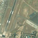
Toncontin International Airport serves as the major airport in and out of Tegucigalpa. The airport's single runway is 1,863 m (6,112 feet) in length. This airport has received much criticism for being one of the most dangerous in the world due to its proximity to the mountains.
More Info:en.wikipedia.org
Location: Tegucigalpa, Honduras (HN)
@ 14.06026000, -87.21537400
Views:
186
Views by date
Rating: Rate as 1 Rate as 2 Rate as 3 Rate as 4 Rate as 5 Rate as 6 Rate as 7 Rate as 8 Rate as 9 Rate as 10 Unrated

Categories

Download

Nearby Maps (50 km): (9)
Save & Tell
+ My Favorites Email This Map
Share
Your Pics Your Story
Update Thumbnails
Google Google Bing Bing Yahoo Yahoo


Post a Comment: (Policies)

Please log in if you don't want to post anonymously (anonymous users cannot post links)

Your Name: Anonymous
Comment:
Anti-Spam Code:Please enter the code below: