Northfield Mountain Tunnel Portal

Northfield Mountain Tunnel Portal
Google Maps Google Maps Birds Eye Birds Eye Yahoo Maps Yahoo Maps
By: skyeye @ 2007-10-29 21:45:11
map #40368
Description:
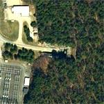
Northfield Mountain pumped storage hydro plant contains an underground generating station blasted out of gneiss. The powerhouse is accessible through a 2,500-foot-long tunnel. Seven hundred feet below the surface, the cavern is longer than a football field and higher than a ten-story building.

The image shows the service road entering the only access to the tunnel. The underground powerhouse flooded during construction in 1972 and suffered a fire in 2002: http://www.masslive.com/news/parchives/f619tunn.html
More Info:en.wikipedia.org
Location: Erving, Massachusetts (MA), US
@ 42.61186974, -72.46721506
Views:
995
Views by date
Rating: Rate as 1 Rate as 2 Rate as 3 Rate as 4 Rate as 5 Rate as 6 Rate as 7 Rate as 8 Rate as 9 Rate as 10 Unrated

Categories

Download

Nearby Maps (50 km): (192)

180 more...
Save & Tell
+ My Favorites Email This Map
Share
Your Pics Your Story
Update Thumbnails
Google Google Bing Bing Yahoo Yahoo


Comments (1)

Feed Feed Post a Comment

skyeye @ 2009-06-25 19:52:10
skyeye picture
Here's a superior view of the portal;
http://ludb.clui.org/ex/i/MA3238/

Post a Comment: (Policies)

Please log in if you don't want to post anonymously (anonymous users cannot post links)

Your Name: Anonymous
Comment:
Anti-Spam Code:Please enter the code below: