British Isles at the Albert Dock

British Isles at the Albert Dock
Google Maps Google Maps Bing Maps Bing Maps Yahoo Maps Yahoo Maps
By: Hinkkanen @ 2006-02-27 14:57:11
map #15019
Description:
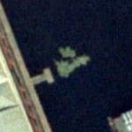
It is really the floating weather map of the British Isles used for the weather show on television. The presenter Fred Talbot jumped around Great Britain and Ireland to show what the weather will be like. it is gone now as the studios have moved to Manchester.
More Info:en.wikipedia.org
Location: Liverpool, United Kingdom (GB)
@ 53.40010700, -2.99172500
Views:
751
Views by date
Rating: Rate as 1 Rate as 2 Rate as 3 Rate as 4 Rate as 5 Rate as 6 Rate as 7 Rate as 8 Rate as 9 Rate as 10 Unrated

Categories

Download

Nearby Maps (50 km): (639)

627 more...
Save & Tell
+ My Favorites Email This Map
Share
Your Pics Your Story
Update Thumbnails
Google Google Bing Bing Yahoo Yahoo


Post a Comment: (Policies)

Please log in if you don't want to post anonymously (anonymous users cannot post links)

Your Name: Anonymous
Comment:
Anti-Spam Code:Please enter the code below: