Corona Satellite Calibration Targets

Corona Satellite Calibration Targets (Google Maps)
No Thumbnail
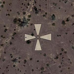
In the 1960s, the Corona spy satellite system was launched with a total of 144 satellites under a top-secret Cold War project. These satellites used ground markers to calibrate their cameras. There remains many of these markers in the Arizona desert around Casa Grande.
2,187 views
Views by date
UnratedRate as 1Rate as 2Rate as 3Rate as 4Rate as 5Rate as 6Rate as 7Rate as 8Rate as 9Rate as 10

Comments

Policies

Please log in if you don't want to post anonymously (anonymous users cannot post links).

Note: VirtualGlobetrotting is an entertainment website is and is not associated with this post, location or person.

Please enable images and enter code to post
Reload

Around the World Mailing List

Share:

Comments

Policies

Please log in if you don't want to post anonymously (anonymous users cannot post links).

Note: VirtualGlobetrotting is an entertainment website is and is not associated with this post, location or person.

Please enable images and enter code to post
Reload