Alder Dam

Alder Dam
Alder Dam
Alder Dam
Google Maps Google Maps Bing Maps Bing Maps Yahoo Maps Yahoo Maps
By: jbottero @ 2006-10-14 16:49:47
map #24631
Description:
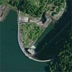
When Alder Dam was completed in 1945 it was one of the tallest dams in the nation, measuring 330 feet in height and 1,600 feet in length. The powerhouse has two 25,000-kilowatt turbine generators that produce about 228 million kilowatt-hours of electricity each year. Alder Dam formed seven-mile-long Alder Lake. With 28 miles of shoreline and 3,065 acres of reservoir area at maximum elevation, Alder Lake is an inviting spot for boaters, water skiers, anglers and picnickers.

More Info:www.ci.tacoma.wa.us
Location: Eatonville, Washington (WA), US
@ 46.80200600, -122.30998600
Views:
389
Views by date
Rating: Rate as 1 Rate as 2 Rate as 3 Rate as 4 Rate as 5 Rate as 6 Rate as 7 Rate as 8 Rate as 9 Rate as 10 Unrated

Categories

Download

Nearby Maps (50 km): (140)

128 more...
Save & Tell
+ My Favorites Email This Map
Share
Your Pics Your Story
Update Thumbnails
Google Google Bing Bing Yahoo Yahoo


Post a Comment: (Policies)

Please log in if you don't want to post anonymously (anonymous users cannot post links)

Your Name: Anonymous
Comment:
Anti-Spam Code:Please enter the code below: