Former SAGE combat control center

Former SAGE combat control center
Google Maps Google Maps Bing Maps Bing Maps Yahoo Maps Yahoo Maps
By: kjfitz @ 2005-07-22 11:14:41
map #5934
Description:On Gunter Air Force Station.


picture


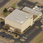
Activated on September 8, 1957, this SAGE Direction Center controlled operations within the Montgomery Air Defense Sector. On 1 April 1966, the Direction Center also became a SAGE Combat Center (SCC). SAGE operations ceased 31 Dec 1969. SAGE was the US air defense system in the 1960s.
More Info:www.radomes.org
Location: Montgomery, Alabama (AL), US
@ 32.40377800, -86.24110900
Views:
295
Views by date
Rating: Rate as 1 Rate as 2 Rate as 3 Rate as 4 Rate as 5 Rate as 6 Rate as 7 Rate as 8 Rate as 9 Rate as 10 6.0 (6 votes)

Categories

Download

Nearby Maps (50 km): (56)

44 more...
Save & Tell
+ My Favorites Email This Map
Share
Your Pics Your Story
Update Thumbnails
Google Google Bing Bing Yahoo Yahoo


Post a Comment: (Policies)

Please log in if you don't want to post anonymously (anonymous users cannot post links)

Your Name: Anonymous
Comment:
Anti-Spam Code:Please enter the code below: