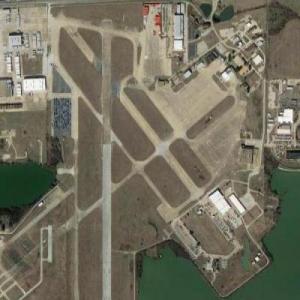
Established in 1932, this was originally the site of Hensley Army Air Force Base. In 1940 the government built a large plant on the northwest of the site to build T-6 Texan trainers and P-51 Mustangs. At its height, the number of people working at the factory was 39,000. The base became the Dallas Naval Air Station in 1943 and the plant was deactivated after WWII (but continues to this day as a private industry: Vought Aircraft.) Throughout the post-WWII years, the base underwent major changes, always becoming a modern military facility right up until its announced closing in 1993. Finally on September 30, 1998, Dallas NAS ceased to exist. Some roadmaps, including Google's, show the site as being the Millennium Dallas Airport. That, apparently, was only a very short-lived venture in the early 2000's. In 2005, Vought Industries took over the Hensley Field runway for shipping (via cargo plane) aircraft parts manufactured in their plant adjacent to the field. The Texas Air National Guard still maintains a small presence only on the extreme southwest corner of the site. Meanwhile, most of the buildings that make up the former Naval Air Station sit abandoned, rusting and falling apart, millions and millions of taxpayer dollars once well used now going to waste. (all info culled from: www.airfields-freeman.com)
Perhaps... just a guess here... maybe? someday, with the ever-growing sprawl of the Dallas Metropolitan area, this can be turned into a working airport again? That would be my vote rather than having the runways torn up and turned into more cookie cutter suburban sprawldivisions, oh, yay, that's just what American needs more of.
Grand Prairie Armed Forces Reserve Complex (Formerly Hensley Field / former Dallas NAS)
© Google Maps
No Thumbnail
© Bing Maps
By AKpilotEMT @ 2006-06-10 16:39:50


Anonymous
@ 2017-06-28 14:18:17
Must be thousands of government (looks like Federal government issue) vehicles stored here now?