Secure National Security Agency (NSA) site


Secure National Security Agency (NSA) site
Google Maps Google Maps Live Maps Live Maps Yahoo Maps Yahoo Maps
By: kjfitz @ 2005-09-02 13:32:14
Description: 
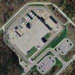
This is an interesting building onthe edge of Fort Meade. It is very secure but flipping to map mode it looks like it isn't actually on Fort Meade like the rest of the NSA Complex.

Map mode says it is on Joseph H Ream Road and Ream was once a director of NSA so I assume it is an NSA site.

BIG airconditioning in back. Perhaps this is a data processing center. The front entrance is fairly fancy. Small parking lot.
Location: Fort Meade, Maryland (MD), United States (US)
@ 39.11725900, -76.76891000
Views: 286
Rating: Rate as 1 Rate as 2 Rate as 3 Rate as 4 Rate as 5 Rate as 6 Rate as 7 Rate as 8 Rate as 9 Rate as 10 Unrated

Categories

Download

Tell
Share
Update Imagery

Nearby Maps (50 km): (1,337)
  1. National Cryptologic Museum (0.6km)
  2. National Vigilance Park (0.8km)
  3. National Security Agency (NSA) (0.9km)
  4. Oak Hill Youth Detention Center (1.4km)
  5. National Security Agency (NSA) satellite downlinks (1.7km)
  6. Image alignment problems (2.2km)
  7. Forest Haven asylum (2.5km)
  8. Brockbridge Correctional Facility (2.6km)
  9. Tipton Army Airfield / Tipton Airport (3.9km)
  10. Bollman Suspension Truss Bridge (5.2km)
1,327 more...


Comments

RSS: Comments RSS: Comments

Anonymous @ 2006-08-04 17:16:10
Anonymous's picture It is the supercomputing facility for NSA.
boothy443 @ 2007-12-18 23:10:31
boothy443's picture aka Tordella SCB

http://www.thebellcompany.com/pdf/ft_mead.pdf

Post a Comment: (Policies)

Please log in if you don't want to post anonymously (anonymous users cannot post links)

Name: Anonymous
Comment:
Anti-Spam Code: Please enter the code below:
Please enable images and enter code to post
Pre-Caching Vote image