A Farewell to Game of Thrones

Whether you’ve bent the knee to Daenerys, Jon, Sansa or Tyrion, chances are you’re looking forward in anticipation the end of Game of Thrones (or aren’t watching the show and can’t wait for this all to be over with).

Over 8 seasons of production, Game of Thrones has filmed in hundreds of locations across Europe (mostly), using everything from iconic architecture to built-for-the show sets.

User kkeps has gathered an amazing collection of over 140 Game of Thrones filming locations that you have to check out:

Below you can check out a sample of these iconic real-world Game of Thrones filming locations!

Doune Castle (Winterfell in Game of Thrones) (Bing Maps)
Doune Castle (Winterfell in Game of Thrones)
Castle Black set ("Game of Thrones") (Google Maps)
Castle Black set ("Game of Thrones")
Great Sept of Baelor (Game of Thrones Filming Location) (StreetView)
Great Sept of Baelor (Game of Thrones Filming Location)
"Prince Oberyn vs. The Mountain" battle site (Game of Thrones) (Bing Maps)
"Prince Oberyn vs. The Mountain" battle site (Game of Thrones)
Jaime trains to fight ("Game of Thrones") (StreetView)
Jaime trains to fight ("Game of Thrones")
The Bloody Gate site ("Game of Thrones") (StreetView)
The Bloody Gate site ("Game of Thrones")
"Prince Oberyn vs. The Mountain" battle site (Game of Thrones) (Bing Maps)
"Prince Oberyn vs. The Mountain" battle site (Game of Thrones)
Highgarden ("Game of Thrones") (StreetView)
Highgarden ("Game of Thrones")
Castle Ward (Google Maps)
Castle Ward
Verdala Palace ("Game of Thrones") (Google Maps)
Verdala Palace ("Game of Thrones")
Nymeria attacks Joffrey ("Game of Thrones") (Google Maps)
Nymeria attacks Joffrey ("Game of Thrones")
Mdina Gate ("Game of Thrones") (StreetView)
Mdina Gate ("Game of Thrones")
Pjazza Mesquita ("Game of Thrones") (StreetView)
Pjazza Mesquita ("Game of Thrones")
Tourney of the Hand ("Game of Thrones") (Google Maps)
Tourney of the Hand ("Game of Thrones")
Tower of Joy ("Game of Thrones") (StreetView)
Tower of Joy ("Game of Thrones")
Vaes Dothrak set ("Game of Thrones") (Google Maps)
Vaes Dothrak set ("Game of Thrones")
Banys Àrabs ("Game of Thrones") (StreetView)
Banys Àrabs ("Game of Thrones")
Battle of the Bastards site ("Game of Thrones") (StreetView)
Battle of the Bastards site ("Game of Thrones")
Itzurun Beach ("Game of Thrones") (StreetView)
Itzurun Beach ("Game of Thrones")
Dany battles the Lannisters ("Game of Thrones") (Google Maps)
Dany battles the Lannisters ("Game of Thrones")

If you want more, definitely check out an interactive map of all 140+ filming locations: Part 1 and Part 2!

Safari #116 – American College Football

VirtualGlobetrotting’s Safaris are weekly challenges to see who can find the most maps from a specific category.

(Our definition of a week is a little strange though, as the last Safari we put on was over 3 years ago!)

Well, dust off your fedoras and binoculars, for it’s time to start the first Safari of 2018!

With the American College Football season entering the last month of regular season games, let’s look for people playing pigskin! Valid submissions must all be in Street View and of people playing football (American). Pictures, art, ads, paintings, murals, etc. are all fine. Players can be of any age, professional or amateur.

For an example of what we’re looking for, here is what the previous Safari’s “Soccer v2” submissions were:

Safari 107 Soccer

The safari will end at 07:00am UTC on Wednesday, November 14. Post your maps to Street View – Safari Submission and another appropriate category for credit.

You can track the progress of the hunt on the Games page.

Good luck and happy hunting!

New look

For those of you new to VirtualGlobetrotting, welcome!

For regular visitors, you may have noticed that we have a new look. We’ve changed the font, layout, icons and logo along with a bunch of other changes.

One important change is the site is now “mobile responsive”, so it looks great on tablets and phones. Give it a try!

If you have any questions or concerns, please head to the developer blog for more details.

Find This Place

Want a challenge?

We’re trying to find the original location of this compound:

I’m offering a $25 Amazon Gift Card bounty for the first person to find the correct location.

Check for more details in the forums.

Google Earth Pro (once $399/yr) now FREE

While the standard version of Google Earth has been free for years, the Pro version offers some additional nice features. It was once $399 per year, but Google has just announced that Google Earth Pro is now available for free to all users.

While the imagery is the same in both versions, some of the main benefits of Pro include:

  • High resolution printing
  • Super Image Overlays (larger overlay textures)
  • Animated movie creation
  • Multi-point mapping
  • Data layers for demographics and traffic

Grab your free key and then download it today!

Photo Safari #114 – Football / Soccer v2

With the World Cup underway, let’s do a quick Safari focusing on the world’s most popular sport. This will be our second Football / Soccer safari.

Valid submissions must all be in Street View and of people playing soccer. Pictures, art, ads, paintings, murals, etc. are all fine. Kudos for graffiti of people playing soccer.

The safari will end at 0700 UTC on Wednesday, June 25. Post your maps to Street View – Safari Submission and another appropriate category for credit.

Good luck and happy hunting!

http://virtualglobetrotting.com/safaris/114-football-soccer-v2/

Here are a few examples from the last Safari:

Playing football (Soccer City) (StreetView)
Playing football (Soccer City)

Playing football (StreetView)
Playing football

Football (StreetView)
Football

Playing football (StreetView)
Playing football

9th Anniversary

On April 10, 2005, Virtual Globetrotting (then Google Globetrotting) launched. Google Maps had just released their first satellite imagery two weeks prior, and our goal was to organize all of the fun and interesting places people were finding from above.

9 years later, Virtual Globetrotting has organized over 180,000 amazing places from all around the world, and is being visited by tens of thousands of visitors a day. We have a great community of people from all over the world with all kinds of interests.

In 2012 we had a good 7-year retrospective, but I thought it’d be fun to look again at some fun milestones and statistics.

Milestone Posts
There are currently 180,453 approved maps in the database. We’re nearing 200,000, which in 2012 we guessed we would hit on October 8, 2015. I think we’re going to beat that estimate.

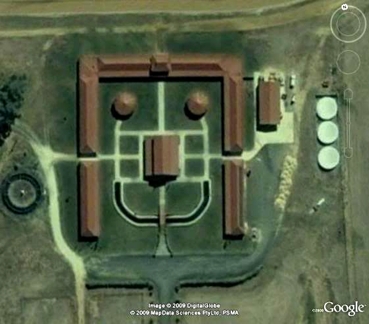
Here’s the first map ever posted:

Philadelphia Stadiums (Google Maps)
Philadelphia Stadiums

The 10,000th map:

Airplane - US Air Force TC-18 over Stanley Draper Lake (Google Maps)
Airplane - US Air Force TC-18 over Stanley Draper Lake

The 100,000th map:

Livry (Le Repas) Isolated British Grave (StreetView)
Livry (Le Repas) Isolated British Grave

The 150,000th map:

Consulate General of Portugal - Sao Paulo (StreetView)
Consulate General of Portugal - Sao Paulo

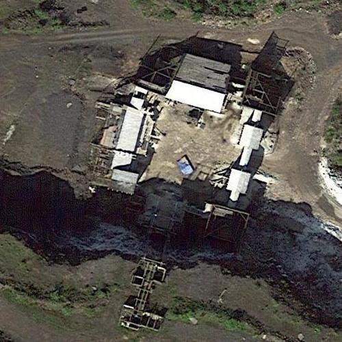
And finally, the most recent map:

Michael Todd Chrisley's House (former) (Birds Eye)
Michael Todd Chrisley's House (former)

Stats

At the time we launched, Google Maps satellite imagery was primarily available in the United States. While US maps dominate at over 88,000 postings, there’s at least one map for every country in the world. Poor Norfolk Island (NF), with only 5 interesting places found.

California leads the US states in most maps submitted, at 21,000, with Florida next at only 8,800 maps.

After Google came Microsoft (Bing) and Yahoo maps. There are 58,600 Google maps, 70,100 Google Street View maps, 4,000 Bing maps, 46,000 Bing Birds Eye maps and a lonely 180 Yahoo Maps. Bing was the most popular with submissions for a while in 2007/2008 when their Birds Eye imagery was far better than anything Google offered, but recently Google (and Street View especially) continues to dominate popularity. We haven’t seen Yahoo update their satellite imagery in several years.

The most popular map with over 500,000 views is Will Smith’s house:

Will Smith's House (Google Maps)
Will Smith's House

While the most commented on map is Allied Forces Southern Europe (AFSOUTH):

Allied Forces Southern Europe (AFSOUTH) (Google Maps)
Allied Forces Southern Europe (AFSOUTH)

Our most popular categories of maps are celebrity homes, including actors, musicians and famous business men/women, while the most popular non-celebrity categories are Events > Abandoned and Events > Movie Locations.

Fun
Virtual Globetrotting likes to have fun, putting on games such as Scavenger Hunts and Safaris. The 21st scavenger hunt is going on right now, called the Everything-But-Street-View Scavenger Hunt, and you should try it out!

I also remember having a bit of fun writing an April Fools’ Day Joke of 2011, saying that we were shutting down because we had finally “collected all 19,709 celebrity homes in the world“.

Thanks
I want to extend a special thank you to all of the community members who are part of the site each day. Virtual Globetrotting wouldn’t exist without your enthusiasm.

The volunteer team of moderators that help ensure the quality of the content cannot be thanked enough. If you’re interested in helping out, please contact us.

Looking Forward
We’re always looking for ideas on how we can make the experience better for you.

If there is anything you want to see out of Virtual Globetrotting over the next year, please don’t hesitate to email us or post a reply.

Thanks sincerely,
Nic, creator of Virtual Globetrotting

New feature: Collections

Today we’re rolling out a beta-test of a new feature on VirtualGlobetrotting: Collections

Collections allow you to create a set of maps that you can describe and order in any way you want. You can keep your collection private or share it publically.

To create a collection, simply log in and head to your Home tab, where you will see a new Collections section. You can add a map from the collection’s page, or from any map’s info page.

All publically available collections can be seen from the new Collections tab up top.

We’re still hammering out some of the details on how collections will work, so if you have any feedback, please let us know.

DigitalGlobe Top Image of 2013

DigitalGlobe, one of the providers of satellite imagery for Google Earth and Google Maps, is hosting a contest to help them choose the best imagery of 2013.

They captured over one billion square kilometers of new satellite imagery in 2013.

They’ve narrowed it down to their Top 20 favorite images, and want everyone else to vote for their favorite:

You can vote on their Facebook page. Voting closes December 17.