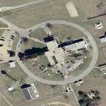
Provides secure satellite access from National Command Authority (NCA), Joint Chiefs of Staff (JCS), and common users to deployed tactical forces. This AFSATCOM system provided the JCS connectivity for the primary and alternate National Military Command Centers (NMCC and ANMCC) with the AFSATCOM system worldwide including the Single Integrated Operational Plan (SIOP) forces, the Commander-in-Chiefs of the unified and specified commands, the National Emergency Airborne Command Post (NEACP), and the Worldwide Airborne Command Posts.
Brandywine Receiver Site
© Google Maps

© Bing Maps
By kjfitz @ 2005-07-19 22:09:15


Anonymous
@ 2008-01-15 12:05:24
Thumbnails are old. The buildings are gone, which is a shame since I worked there in the 70's.

Anonymous
@ 2009-12-21 16:30:14
Really is sad. I lived in the dorm in 1990.

Anonymous
@ 2010-08-06 21:57:34
It's all gong underdround now, with satelites and all new techonology. Look to the right, access down a path and into a small structure leading underground.